Sunday, August 28, 2011

Sunset Crater and Oak Creek Canyon


Wednesday we took a drive to Sunset Crater and Wupatki National Monuments north of Flagstaff.  The crater was formed about 1000 years ago.  In a one year time frame this volcano grew over 1000 feet, belching cinders and lava flows which covered the surrounding landscape. 

  This cataclysmic event disrupted the people who inhabited the region forcing most to abandon their homes and move elsewhere.  A hundred years later some returned to farm.   They settled at the Wupatki pueblo which they constructed in the desert below the crater. 


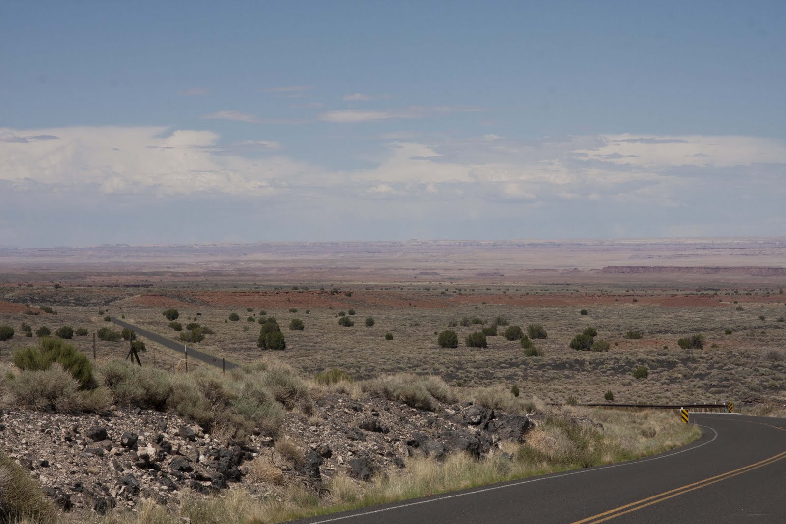
 They must have been hardy people to live in this high desert environment.  The area surrounding the crater is covered with hardened lava and now is covered with an emerging Ponderosa Pine forest at the higher elevations.  As we descent from the crater toward the pueblo at Wupatki we pass from the pine forest to a landscape dominated by One Seed Juniper and grasses.  A further drop in elevation and we are in a desolate, desert environment. 


 This is where they pueblo was constructed.  It was interesting to see where this village was placed.  Strategically they chose a ridge line that provided the high ground for defense.  The buildings used the large boulders which lined the ridge as the foundation and then they simply stacked the flat sandstone rocks one atop the other and held them together with mud. 

 Between the walls they used rubble to fill the void which served as insulation from heat and cold.  Below the village were two circular kivas which were used for religious ceremonies. 

In the distance one can see the Painted Desert with its hues for red and white earth.  Here it was hot—and one wonders why they chose this desolate, dry land for their home.

Thursday was hiking day.  We left early so we could reach the Oak Creek Canyon hike before it became hot.  On arrival we were greeted by a very gruff attendant who demanded a $9.00 entry fee.  I offered my Parks Pass and was abruptly notified that it would not work here.  This trail was under the direction of a private company and they did not honor the pass.  So I paid the fee and then asked if they had a trail map.  Yes, for a mere $1.00 I could have one.  The map I was given was about the size of a post card and not really very informative.  Nevertheless, we headed up the canyon trail which I must say was breathtakingly beautiful.  The tail follows the west fork or Oak Creek up the canyon.  Oak, Sycamore and Ponderosa Pine along with huge Cottonwood trees line the trail.  Towering 500 feet overhead are massive rock cliffs providing an imposing spectacle.  As the trail twist and turns up the canyon you must make several crossings of the creek.  There are no bridges and you must carefully step from rock to rock to keep from getting wet.  Ermine went part of the way with me and then decided to turn around and go back and read instead.  I continued up the trail, however, I didn’t make to the top which is 3 miles one way.  Instead I made it about 2 before turning around.  Below are some photos of the canyon as you hike up the trail.  


  I imagine this would be a great birding trail in early May as the resident breeding birds and migrants return.  It is now late August so many have already departed for warmer climes.  I did get great looks at Red-faced, Virginia and Olive Warblers, Steller’s Jay, Lesser Goldfinch, and a pair of Western Tanagers.  I could hear many other birds in the canopy but could never get enough of a look to identify them.  I am considering a TOS trip to this area next May and I have asked Rhandy Helton to join me as a co-leader.  The plan would be to fly into Phoenix, rent vans, pick up the participants at the airport and drive to Flagstaff; it is only 150 miles of interstate from Phoenix.  There are many areas of birding interest in this area and we have never had a TOS trip to the region.  The reminder of our day we planned to visit Slide Rock State Park to have our picnic and swim.  Unfortunately, the monsoon rains had other plans.  As I returned from the trail it was lightening and then the rain started. We decided to forgo the swim and return to camp.  This would be our last outing in the Flagstaff area as we are leaving for California on Saturday morning. 

Friday we headed to Flagstaff to the movies.  “The Help” was our choice and what an indictment of the South it was.  My father was born in Mississippi and I had the occasion to visit my Great Grandmother there in 1952.  I can tell you from my experience that blacks in Mississippi were treated with great disdain.  I remember seeing a sign on the outskirts of town that said “Nigger don’t let the sun set on you in this town.”   I grew up in Corpus Christi, Texas which had a very small black community and one isolated from the rest of the community.  It wasn’t until my senior year that we had a black student in our school.  As a result I was somewhat oblivious to the segregation and its consequence for blacks in the South.  I am glad that this chapter in American History in almost shut.  Today I have two beautiful grandchildren whose father is black and I am very proud of them.

Wednesday, August 24, 2011

Sedona--Tourist Trap Extraordinar


Upon arrival at the Kaibab Lake campground we were fortunate to find a very nice site in which to camp. 

This newly re-opened forest service campground is the nicest I have ever seen.  The site we selected has an all concrete pad, large patio, table, fire ring and grill.  With my senior discount the cost for 6 nights is only $54.00, a bargain.  We have no hookups, but we really don’t need them.  Water is available a short distance away should we need to replenish our supply before we leave for California.  After supper we walked to the lake to view the evening’s sunset, and we were not disappointed.  The golden glow of the western skyline viewed through the backdrop of tall Ponderosa Pines, warm sun painted clouds on both horizons, and the inverse reflections of the surrounding landscape in the still water of the lake made for an awe inspiring sight. 


 I have set up the hummingbird feeder and the wars have already begun.  At least five female Black-chinned Hummingbirds are competing for control.  I suspect a rufous will appear soon and end their reign.  Other birds noted so far include Steller’s Jay, White-breasted Nuthatch, Western Bluebirds, Common Raven, Harry Woodpecker and a pair of Osprey complete with nest.  I did get some good shots of the Ospreys this time.


  In the morning we are off to check out Sedona.

The drive down Oak Creek Canyon is spectacular, maybe even more spectacular on the return leg. 


Along the way we stopped to a take a peek at Slide Rock State Park where we will go on Wednesday after we hike Oak Creek Canyon.  Slide Rock SP is supposed to one of the ten best swimming holes in the nation.  It did look pretty interesting.  Sedona is nothing but a tourist trap--blocks and blocks of jewelry stores, people hawking time shares and condos, physic readers, art dealers and restaurants.  The art of the hard sell is alive and well in Sedona.  As you might gather this is not my kind of place.  Ermine enjoyed visiting the numerous shops, had a card reading and checked out a couple of jewelry and boutiques.  The most amazing aspect of the day was Ermine bought NOTHING.  Just before leaving I did my shopping at a local birding store.  There I purchased a couple of guide books to local birding hotspots in the Verde Valley and Flagstaff, a bird feeder and seed and Ermine pick up a nice CD that incorporates bird songs in with the mainly bluegrass music of the album.  I have incorporated a few of the scenic pictures taken of the unusual formation found around Sedona.  These formations are worth the drive and enduring the Sedona salesmen. 

Tuesday we spend in camp.  We had a cooling thunderstorm in the afternoon and the broke out the inflatable kayaks to do a little kayaking on Lake Kaibab.  We soon discovered that Ermine’s kayak had a slow leak somewhere and returned to shore to see if we could rectify the problem.  After a thorough investigation we determined that a leaking valve was the culprit.   Fortunately, we received a replacement when we purchased the kayaks in 2002 and the new valve fixed the problem.  Since we slept in late this morning, we will remain in camp and return to the lake to do some kayaking instead of the hiking and swimming we had planned in Oak Creek Canyon.  We will return to the canyon tomorrow.

Mule Skinner


“You can change your mind now, and we will give you your money back, no questions asked.  But if you leave the corral on your mule, it’s too late.  You stay with us and on your mule the rest of the way.  You get off your mule; you’ve got to walk back.”  Those were K-Bar’s last words to us before we mounted our mules and went over the rim down the Bright Angel Trail into the Grand Canyon. 

Nobody said much, and most of us, including me, were thinking, “What have I gotten myself into?”  We would be descending on a narrow, twisting trail down over 4,000 feet from the South Rim to Phantom Ranch, through tunnels, a suspension bridge over the Colorado, and doing it all by early afternoon.  Most everyone had a death grip on their saddle horn and looked pretty pale when we looked down the zigzagged trail onto the tops of hiker’s heads below us.  As we paused before the first tunnel, our mules turned sideways and hung their heads out over the abyss, nonchalantly flopping their big ears and swatting flies with their stubby tails. 

 My mule, “Zug-Zug” was huge—at least 16 hands, round as a barrel, and hard muscled.  We were all given “mule motivators,” the politically correct term for crops, but these didn’t impress our mules much.  They proceeded at pretty much their own speed, being hustled up by  K-Bar and Kenny’s voices as much as anything.  By the time we had reached Indian Gardens a couple of hours into the ride, we were starting to relax.  I realized that a mule is very different from a horse, laid back, spookless, and sure-footed, looking before it placed each foot.  Only one stumble on the whole trail, which was so steep we were going down stair steps most of the time.  I saw why mules were the animal of choice to ride on this breathtakingly beautiful but hair raising trail.

I was beginning to trust my mule by then, and it was a good thing, because the scenery was jaw dropping.  We descended through successive climate zones, from pinion pine and juniper scrub at the rim, then ponderosa forest, then cottonwood and willow groves at Indian Gardens and followed a clear tumbling stream down Pine Canyon before descending into the dark inner gorge. 

There we lost the morning sun for a while as we descended in a cloud of dust through layers and layers of multicolored rock.  We kept a fast pace, as it was getting hotter by the minute as we descended.  We needed to be at the bottom before the heat of the day, as temperatures were usually 20 degrees hotter than the rim.  We were continually encouraged to drink our water as the air is so dry that it is easy to get dehydrated without knowing it. 

Finally, after slip-sliding our way straight down for what seemed like forever, we glimpsed the Colorado, swift and green, below.  Several yellow rafts were moored at a small beach, and a rafter mooned us as we passed.  Maybe we were kicking stones over the edge inadvertently?  We saw the silver bridge used by hikers ahead of us, but we were headed for the Black Bridge, constructed in the ‘30s.  Before we could cross, we had to pass through a tunnel several hundred feet long and black as the Carlsbad Caverns, ducking our heads to keep from hitting them on the low ceiling.

  As soon as we came out into the sunlight again, we were on the bridge, suspended at least 100 feet over the swirling river.  I could see know why they prohibited swimming in the river.  It was swift and full of currents, whirlpools, and rocks, and would no doubt drown even an experienced swimmer quickly.  The bridge was only 1 mule width wide, and these sure footed animals quickly tripped across the 2 plank wide span like gymnasts on a balance beam.  We left the Colorado on the other side and made our way up the canyon formed by Bright Angel creek to Phantom Ranch.  A series of cabins built in the 20s and designed by a famous woman architect from native materials, the camp is situated in a grove of cottonwood trees and green meadows, a stark contrast to the grim canyon walls surrounding us on all sides.  Although the temperature was 102, the dryness of the air made it seem not nearly as hot as it was in Texas! 


We spent the afternoon lolling in the creek, staying cool in the shallow clear water and damming the rocks to create soaking pools.  A talk by Ranger Mandy on the successful condor population of the Canyon, introduced in the early 1990s was followed by a delicious meal of steak, baked potatoes, cornbread, peas, corn, and chocolate cake for dessert.  Another talk was presented in the evening about the Kolb brothers, the crazily adventurous early photographers and promoters of the Canyon, followed by a scorpion hunt for anyone who wanted to go (the scorpions glow green at night).  I was too tired, however, to participate, and went to bed ridiculously early I was so tired.  

The morning started early, as we were to be packed up and ready to eat breakfast at 6:30.  After pancakes, eggs, bacon, peaches, and coffee, we headed out on a different trail, the South Kaibab, a shorter but steeper ascent out of the canyon.  We rested our mules often, and our guide, K-Bar, entertained us with tales and interesting stories of the canyon during our stops.  The mules needed it, because the trail was exceedingly steep.  Often we could see the bellies of the mules in front of us from below as we ascended the hairpin turns of the trail.  Names such as “Jesus corner” because of what you might say as you rounded the corner, “Ooh-ahh point”, and Jacob’s ladder were some of the landmark names we navigated.

We reached the top by noon, and received our official certificates as “Master Mule Skinners” before returning to Bright Angel Lodge.  Sore and tired, but thrilled at having experienced an adventure of a lifetime, I decided I might even be fool enough to do this again in the winter, when the snows at the rim give way to the warmth of the canyon, and the crowds are thin.

Sunday, August 21, 2011

Catch Up: Flagstaff to Grand Canyon


Highway 87 from Payson to Willcox is a very scenic drive.  Once again the climb is often steep and winding as you pass through a portion of the Tonto National Forest.    Dense pine mixed with oak, rocky outcroppings and a deep blue sky create a pleasing sight as we motor toward our destination near Flagstaff.  There we plan on spending a couple of days before heading to the Grand Canyon and Ermine’s destiny—a mule ride into and out of the Grand Canyon.  We head north on Lake Mary Road just outside the small community of Cliff Wells.  Now we are above 7,000 feet again and Ponderosa Pines dominate the landscape.  Today's entire drive is less than 100 miles.  We veer off Lake Mary Road for a swing through the community of Mormon Lake.  At one time this was a massive lake settled by Mormon pioneers in the 19th century from nearby Utah.  Today it is mostly a meadow, except I am told in the early spring when the snow melts and it is again a lake.  From all of the RV parks along the road it is clearly a summer destination for those seeking relief from the desert heat of Phoenix.  I don’t recommend the campground we chose to camp for these two days, Asbury Lake.   If you do be sure to go to your dentist before attempting the four mile drive into the campground.  The washboard road will shake every filling in your head.   This forest service campground is rustic, set on one of the lakes in this region that hold water year round, is a favorite of fishermen who come to fish in the lake stocked with trout, and is outside the adjacent dense Ponderosa Pine forest.  It is more attune to a high desert landscape supporting some Ponderosa Pine,  but primarily One Seed and Utah Juniper.   Our camp host tells us that the best fishermen in this area are the numerous Ospreys who make this lake their summer home.  At almost any time one can see them circling over the lake looking for their daily repast.  I was just lazy and failed to take any pictures of them, as I already have several good photos of Osprey.  However, I took the occasion of putting out the hummingbird feeder and in no time a female Rufous Hummingbird staked her claim, defending her captive "flower" from Broad-tailed and Black-chinned Hummingbirds that dared approach.  Ultimately her claim was jumped by a male of her species who drove her off.  And he was very cooperative, allowing me to take numerous photos over the next two days.

 I took two early morning walks looking for birds while at Asbury Lake which produced the following species—Mountain Chickadee, Lesser Goldfinch, Great Blue Heron, Western Tanager (one of my favorites),  Black-crowned Night Heron, of course Osprey, Chipping Sparrows and a Western Wood Pewee.  We did take the opportunity to visit Flagstaff, a very nice city with a vibrant downtown filled, of course, with shops dedicated to tourist which provides major economic support for the community.  I thought Flagstaff a very nice place to visit.  Ermine did some looking and shopping while I took the opportunity to get a haircut.
Thursday we broke camp early and headed for the Grand Canyon.  On the way we checked out the newly re-opened Kaibab Lake Campground near Williams, AZ and decided that we would return there after our Grand Canyon stay.  Another hour and we were at Trailer Village in the National Park, our home for the next three days.  Ermine had to check in with the mule ride people for her Friday morning departure.  There are several requirements which one must meet—you cannot weight more than 200 pounds including your gear, you must be in good health and speak English.  They provide you with a wine skin bag to tote your water in (and they provide you with instruction of how to prepare it-- fill it with water and the provided lemon juice and let it soak overnight), a rain slicker, and a small plastic bag into which you must place all items you are going to take on the trip.   And they don't allow much.  They then instruct you to go home and return to the corral no later than 6:50 AM in the morning.
Up at 5:00 A M, some coffee, final check of necessary gear and we are off to the corral and Ermine’s long awaited ride into the canyon.  Following a lecture on the rules of the trail and instructions on how to handle their mule, each of the participants is assisted onto their companion animal for the trip. 


The trip will take approximately 5 hours to reach the camp at the bottom of the canyon.  I take pictures of Ermine as she leaves the corral and wish her luck.  She will return around noon tomorrow.

I then head to the Little Colorado Overlook some 45 miles east, stopping along the way at various canyon overlooks for photo ops.  The landscape changes dramatically as I make the drive, from dense Ponderosa Pine forest to arid, desolate desert of the Navaho Reservation.  I will attach several pictures of the canyon landscape below.  The Grand Canyon is one of the most photographed areas in the world and has been documented by some of the greatest landscape photographers, so what I can add will be of minimal consequence.  However, the canyon is a spectacular scene and one that everyone should visit.  From the South Rim to the North Rim of the canyon it is only 10 miles across but to get from one side to the other it is over a 150 mile drive and takes several hours. 


I am sure you get the idea.   One of the points of interest along my drive is Desert View, an area that offers a very panoramic view of the canyon.  There one can climb into the observation tower for a grand look out over the landscape and be joined by the hundreds of people, speaking a multitude of languages.  I think English is definitely a minor language heard here as international visitors seem to dominate the crowds—and there are very large crowds everywhere you go.  I also had the opportunity to do a little jewelry shopping.  Every scenic overlook on the Navaho Reservation supports numerous stalls where Native Americans offered their wares for sale.


I only did a little birding while here.  A family of California Condors have established a residence below Bright Angle Lodge in the park.  They are frequently seen in the late afternoon riding thermals over the canyon.  I only got one distant look at a condor as it soared over the canyon and out of sight.

 I did, however,  get to photograph a Pinion Jay and dark phase Red-tail Hawk, along with a very distant shot of the California Condor. 


 I would say that this part of the trip was more about scenery than wildlife.  And Ermine returned from her decent into the canyon, a bit sore and tired, but very satisfied with her experience. 

 I will let her write her tale of her trip and post it to the blog later.  Now it is off to Williams where we will camp and make day trips to Sedona and Slide Rock State Park-- supposedly one to the 10 best swimming holes in the US.  I will close this episode with a shot of sunset on San Francisco Peak I shot while at Asbury Lake.


The sunsets here in Arizona are really beautiful.

Saturday, August 20, 2011

The Mogollon Rim


From Silver City we head northwest traversing a high desert landscape of grasslands punctuated by tuffs of bear grass.  The monsoon rains have greened up the pastures for the local ranchers who I am sure are enjoying the moment.  In the distance are the Mogollon Mountains which we must cross to reach Arizona.  The climb is difficult at times as we wind our way up and over an 8000 foot pass.  Lush green meadows and dense ponderosa pine forest replace the open grasslands of the high desert.  Leaving behind the last New Mexico community, Luna, we tumble down the mountain side into Arizona.  It is lunch time, and in need of a driving break, we swing into Luna Lake near the town of Alpine.  Several years ago we camped here for several days.  From the RV I can see hundreds of American Coots and numerous Eared Grebes with their hatchlings swimming about.  From a small pier that juts into the lake, I am able to get some good photos of the grebes.

The walk back to the RV produced a Black Phoebe, Western Bluebird, and a Brewer’s Blackbird as well as an unidentified empidonax flycatcher. 


 I also encounter the first of many Colorado Squirrels. 

 The weather is refreshingly cool, as we are now above 8000 feet, and the usual thunderheads are around, building to produce the afternoon thunder storms common during this monsoon period here in the mountains.  A quick lunch and we are singing “on the road again”, the song Willie Nelson made popular.

Our destination is Heber, Arizona and the Mogollon Rim where we plan to camp for a couple of days.  We are making great time until I make a mistake and follow the wrong Highway 260.  I drive fifteen miles before I realize my error and then have to backtrack to Duce of Clubs Avenue where I make the necessary correction.   We are in Show Low, Arizona.  The community derived its name, so the story goes, from the local rancher who won his ranch there in a poker game by “showing low”, and in poker, you can’t get any lower than holding the duce of clubs.  If I had his luck I would not have made the wrong turn earlier.  Now we rush down the last 60 miles to our destination.  We are passing through the largest stand of ponderosa pine in the world.  This is part of the Apache-Stigraves National Forest, I place I spent two weeks doing birding surveys for the Forest Service in 1997.  Many of these pines reach over a hundred feet into what, for now, is a deep blue sky.  This doesn’t last!  As we approach our campground we are struck by one of those common monsoonal deluges which are nearly daily afternoon occurrences.   So we pull off into the nearby welcome center to wait it out before proceeding on to Aspen Campground, our destination just across the highway.  Finally, nearly five in the afternoon, we are at our campsite.

I awake around five in the morning and as I look out the window I am struck by the sunrise I see through the trees. 

 I grab my camera and take a couple of shots.  This is the result.  Following breakfast we set out to explore.  Our first stop is the viewing area that looks out toward Payson, Arizona over the “rim”.   The Mogollon Rim supports drops of between 1200 and 2000 feet that are nearly vertical along its 200 mile run. 

The sharp edge of the rim is what causes those heavy, afternoon thunderstorms.  As the warm, moist air from the Gulf of Mexico and the Pacific sweep across the low lying desert below, they are suddenly forced upward by the rim.  As they jet into the much cooler air of the higher atmosphere, they explode into afternoon thunderstorms.  The rain runoff flows into the Little Colorado, the Salt and the Gila Rivers which ultimately feed the Colorado River flowing through the Grand Canyon.  Our morning tour includes a visit to Woods Lake where numerous fishermen tried their luck for newly stocked brown trout, then Willow Lake were several kayak groups paddled about while a lone osprey circled overhead (I wonder if it is a descendent of the lone osprey I found here on a 1997 Breeding Bird Survey), a large contingent of hatch year Mallards swam about,  and finally the visitor center and another look out over the rim.


Back in camp we lolled the afternoon away taking naps, sitting under the towering ponderosa pine, and enjoying the refreshing cool seventy degree temperatures of the afternoon.  Occasionally I would take a walk about searching for birds and I was not disappointed.  In a Mott of Gamble Oak a small group of songbirds flitted among the branches searching for insects to devour.  In a very short time I found Olive, Red-faced, Grace’s, Lucy’s and Black-throated Gray Warblers, Acorn Woodpeckers, Western-wood Pewee, White –breasted Nuthatch, Steller ’s Jay, Hutton's Vireo, numerous Western Bluebirds, a Northern Flicker and a gray-headed form of Dark-eyed Junco.  All within a 100 yard walk from the RV.  


  As sunset approached we were treated to another magnificent experience.   A lone, dead ponderosa pine, in which I had watched several woodpeckers and hatch year Western Bluebirds spend the afternoon feeding, was suddenly lit up by the descending rays of the sun, producing a strikingly beautiful scene. 

 Thus we ended our stay along the Mogollon Rim, a beautiful place to visit, one that should be on your bucket list.